
Watching the excitement and intense preparation of my runner friends preparing for the Hard rock Endurance Run (and many other!) ultramarathons, I decided that the mix of interests was too much for me: I had to write about the geology of the Hardrock 100 race.
I am a runner and a geologist.
I’ve spent most of my running on the roads, but my PhD research focused on how the Colorado Rockies formed.
As part of my research, I hiked, ran, and collected rocks from all over the mountains of Colorado. The Hardrock Endurance Run travels over much of the area I studied: the San Juan Mountains.

Only have time for a quick read?
Click here to skip to the geology of the San Juan Mountains.
Going somewhere specific? Skip to the geology of key points like aid stations by clicking here.
About the Hardrock 100
The Hardrock Endurance Run is a fabled race amongst trail and ultra runners. The course is about 100 miles (102.5, precisely), and has incredible topographic features: the course has a cumulative vertical gain of 33,197 feet of climb and 33,197 feet of descent for a total elevation change of 66,394 feet.
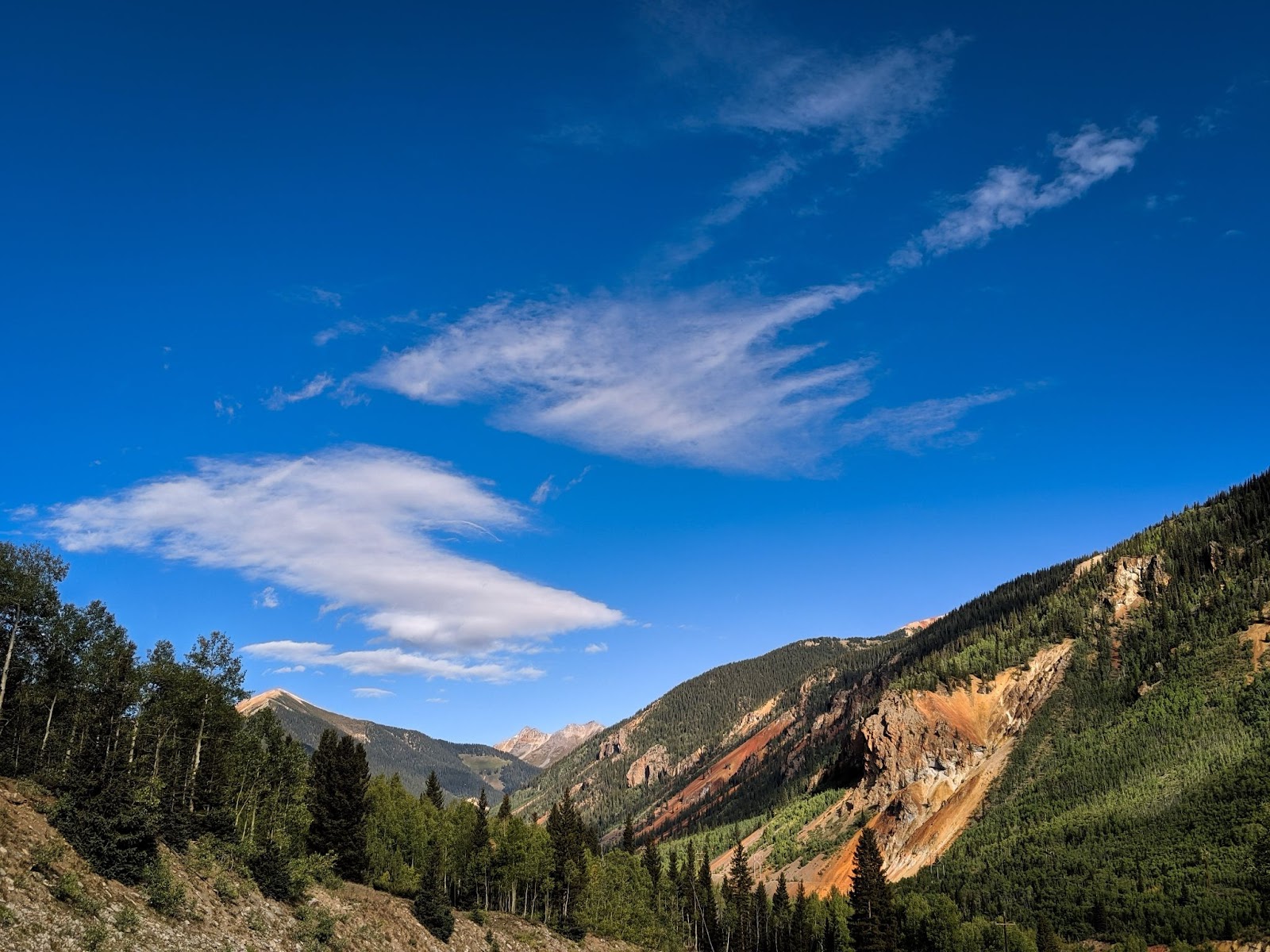
This rugged topography is not the only challenge that deals with elevation: the course averages an elevation of 11,000 feet above sea level. The course starts and ends in the historic mining town of Silverton, CO at 9,318’ and reaches a high point of 14,048 feet when runners summit Handies Peak (this year at 38 miles into the 100 mile course). (Image)
The course is one giant loop. The direction the loop is run changes each year; in 2023 the run will be done counterclockwise (so athletes will head east out of Silverton, heading towards Cunningham Gulch.
As you can imagine, much of this race is done on 4 wheel-drive roads, trails, and across country and above treeline. Runners must remain on the specified route, and are often quite isolated in this remote, wild country. The race has a cut off time of 48 hours, while fastest times were both set in 2022 by Courtney Dauwalter (26:44) and Kilian Journet (21:36). For perspective on these running superstars, the average finisher.
San Juan Mountains Geology
The San Juan Mountains in southwestern Colorado have some of the most spectacular geology and landscape in the world. San Juans showcase vibrant, multi-colored volcanic deposits, ancient metamorphosed bedrock, brilliant-colored sedimentary rocks, all of which were carved by glaciers and continue to be shaped by the rushing streams and modern events.
Geologic Overview
The geology seen in the San Juans falls into 4 types: volcanic, basement, sedimentary, and modern. This is a bit of a simplification, but for the most part, the mountain peaks are volcanic, the canyons are carved of basement rock, sedimentary deposits, and finally, young/modern streamflow and erosional deposits. Keep in mind that “young” to a geologist can mean….anything less than a million years old!
Volcanism
Many of the brightly colored, layered peaks of the San Juans are tipped in volcanic rocks. These rocks were erupted from a number of calderas. Calderas are volcanoes that erupt so much of their magma chamber out at once, that they blow their “lid” and the remaining “lid” and walls of the volcano collapse inward. A few famous calderas are found in Yellowstone, Valles Caldera, and Crater Lake.
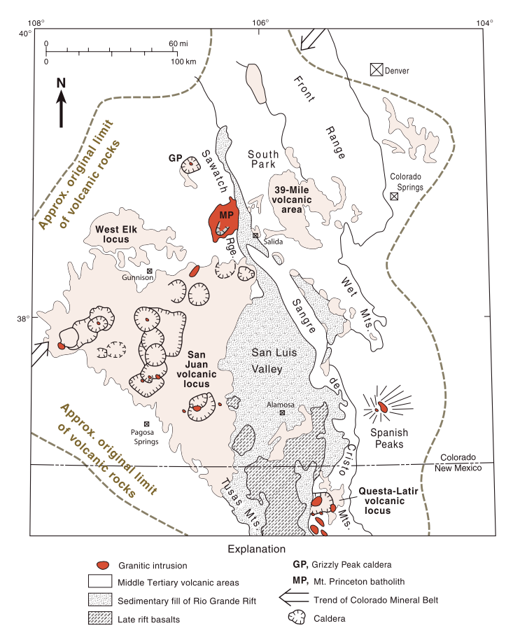
The San Juans are made up of a cluster of calderas that erupted massive amounts of tuff, rhyolite, basalt, and other volcanic units largely between about 23-38 million years ago. This composite caldera volcanism is part of what is known as the “Southern Rocky Mountain Volcanic Field,” and includes volcanism near the Front Range at Spanish Peaks, the West Elks near Gunnison, Mt. Princeton near Buena Vista.
These calderas together erupted 30 ignimbrites: the hardened rock remains of the hot (500-1000°C), roiling outflows of combined molten particles (ash, pumice, and other rock fragments) and abundant gasses that violently erupt from a volcano and flow with incredible speed over a landscape. These frothy outpourings cool quickly, forming a “glassy” matrix of rock called “tuff.”
Much of the volcanic units you see in the region of the Hardrock 100 are the outpourings from the Silverton, Uncompahgre, San Juan, and Lake City Calderas. The Silverton, Uncompahgre, and San Juan Calderas erupted about 28 million years ago, while the Lake City Caldera erupted 23 million years ago, one of the youngest San Juan volcanic field eruptions.
Today, we see the eroded remnants of these calderas. This area has actually given geologists a really excellent way to look at the inner workings of calderas. Thanks to the hot fluids that accompany volcanism, the region is also rich with precious minerals and metals: the town of Silverton was literally named for the silver deposits in the region. The San Juans are part of what is known as the Colorado Mineral Belt, and have a rich mining history, beginning in the 1870s with the discovery of gold and silver deposits. Silverton, Ouray, Telluride, all on the Hardrock 100 route are mining towns, while nearby Creede and Lake City are also of historical mining importance.
Gold and silver are deposited in the San Juan region by the process of
Basement Rock
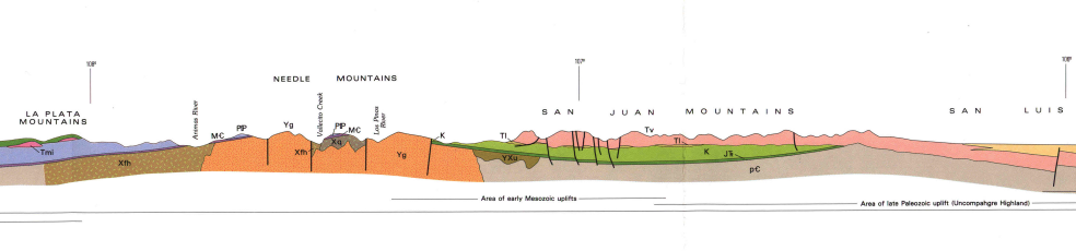
Underlying younger sedimentary and igneous rocks lie what geologists call “basement” rocks: old, crystalline rocks that have been around (in this instance) for well over a billion years. In the cross section below, basement rocks are labeled Yg, YXu, Xh, Xfh, Xq, and pC. These are different sets of sedimentary, igneous, and metamorphic rocks that have all been around since Precambrian time (more than about 700 million years ago.
Basement rocks include quartzite, conglomerates, shales, slates, and granites. In places, the granites are nearly 2 billion years old, nearly half the age of the Earth.
Sedimentary Units
Sedimentary units on the course of the Hardrock 100 are exposed in canyons and slopes of the western part of the 100 mile loop. These include Devonian-Ordovician age limestones, quartzites, and dolomites and strikingly red sandstones and conglomerates of Triassic-Permian age, as well as Eocene conglomerates.
Glacial and Fluvial (Stream) Deposits
Much of the San Juans have been glaciated over the past million years. The most recent glaciation the San Juan area occurred roughly between about 80,000-11,000 years ago. The remnants of glacial features that formed during this time of mountainous glaciation are visible to day as in sharply carved ridges, cirques that house alpine lakes and moraines. Moraines are the tumbled, ground up material that glaciers pushed out of their way as they flowed; we see these are ridges or deposits of jumbled rocks, silts, and soils.
Other younger deposits visible in the area include landslide deposits and modern stream deposits along actively flowing or seasonal streams.
Key points of interest
Geology along the course of the Hardrock 100 is awesome, and here I work to tie specific locations to their geology. This includes high points, stream crossings, and aid stations.
Start & Finish
The start and finish of the race, in Silverton, CO take place on a relatively flat-ish center of the Silverton Caldera. The town itself sits on glacial ‘drift’: deposits of sand, gravel, clay, and boulders that were deposited by a glacier, or by the melting waters of a glacier.
Cunningham Gulch Aid Station (mile 9.3)
This aid station sits on an area of gneiss. Gneiss is a metamorphic rock that is typically striped. Gneisses form from the heating of sedimentary or volcanic rock under great pressures.
One way these stripes, or “banding” form is when the pressures the rock is experiencing are greater in one direction than the other. The stripes form perpendicular to the greatest pressure. Often, these pressures can change and shift over millions of years, this can make the striping look squiggly. Darker bands contain more “mafic” minerals, those that contain abundant magnesium and iron. Lighter bands are more “felsic;” this means they have more feldspar or quartz minerals, and relatively higher amounts of aluminum, sodium, and potassium.
Just south of this aid station is an outcropping of the Leadville/Ouray Limestones, a Mississippian-Devonian-aged (~320-420 million year old) limestone that can be visible in tall, gray, cliffy formations.
Maggie Gulch Aid Station (mile 15.4)
The Maggie Gulch Aid Station sits on andesitic lavas from the Silverton Caldera. Andesitic lava is an intermediate-chemistry lava: part way between basalt (mafic) and rhyolite (felsic). This type of lava typically flows thickly from eruption sources, erupting at 900-1000°C. The unit cools as a gray-black volcanic deposit, and visible throughout the course.
Following this aid station, athletes cross many young landslide deposit areas, which are often seen as meadows or open areas along valley bottoms, as well as covering the slopes of higher topographic areas.
Sherman Aid Station (mile 29.8)
The Sherman aid station showcases one of the first instances of basement rock. Here, while the Campground itself sits on modern alluvium (material deposited by the stream), we see granitic rocks of about 1.4 billion years of age exposed in the canyon walls. This is the Cataract Canyon Granite, a massive, light pinkish rock with medium grain size.
Handies Peak (mile 38)
Handies Peak is carved of volcanic rock. Specifically, the peak is crowned in tuffaceous mudflow breccias: a tumbled mix of violently erupted rock fragments held together by a sandy glue, or, “matrix.” This and the nearby tuffaceous sandstone that also blanketed the landscape as part of the same eruption, this unit appears gray with a slight greenish cast. The peak has been carved by glaciers and continues to be eroded today. Landslide ande debris flows cover the flanks of the mountain in scree.
The route continues, with mountains here made of the caldera outflows and caldera walls.
Ouray (mile 58.6)
Beginning the descent into Ouray, athletes run into the Uncompahgre Formation, an ancient 1.7 billion year old quartzite-slate formation. This unit is named for it’s “key” location near the town of Ouray in Uncompahgre Gorge. This rock is a gray to black unit over 8000 feet thick. Originally deposited as marine and fluvial sandstone, mudstone, and shale, the sediments were metamorphosed and transformed into what we see today.
The cliffy walls surrounding Ouray also host the Leadville Limestone and Gilman Sandstone, which the town of Ouray is built upon. These are underlain by the Hermosa Formation, a 300-million year old red sandstone, conglomerate, and shale that is noticeable throughout southwestern Colorado due to its repetitive sandstone, siltstone, and limestone layers.
Leaving Ouray, a small outcropping of intrusive felsic rock is exposed east of Thistledown campground. This light gray granodiorite formed as a laccolith, a mushroom-shaped intrusive body that cooled beneath the crust.
Governor Basin (mile 66.2) & Kroger’s Canteen (mile 69)
This return to high topography between Ouray and Telluride allows expansive views of the southwestern apron of the San Juan volcanic field. These ash flow tufts are crumbly, steep sided, and relatively erodible.
Telluride (mile 74.7)
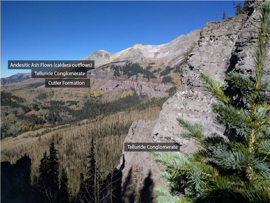
A switchback dive into the box canyon in which Telluride is built brings athletes down from the volcanic deposits through pre-volcanic and syn-volcanic sedimentary unit of the Telluride Conglomerate.
This unit is near and dear to my heart, as it was one of the main foci of my dissertation research! As the calderas of the San Juan filled up their magma chambers, they caused the land surface above to bow up, or be elevated. This prompted rapid and high-energy erosion of these units, and as volcanism started to erode, the Telluride Conglomerate formed of this jumble of eroding material and very early volcanic debris. The Telluride Conglomerate is visible as the red-purple cliffs that stand on the eastern end of the Telluride canyon.
Below the Telluride Conglomerate, a quick succession of Jurassic Morrison, Wanakah, and Entrada Formations exist. The distinctive bright red Triassic Dolores and Permian Cutler Formations form the valley of the town, and just south of the town as athletes head up Bear Creek, back through the Telluride, and return to the San Juan volcanics for their last approximately 30 miles of race.
A similar volcanics-Telluride Conglomerate-Cutler-Telluride Conglomerate-volcanics experience is seen in the descent into Ophir.
Clear Lake is a glacial cirque lake, carved by a now melted glacier.
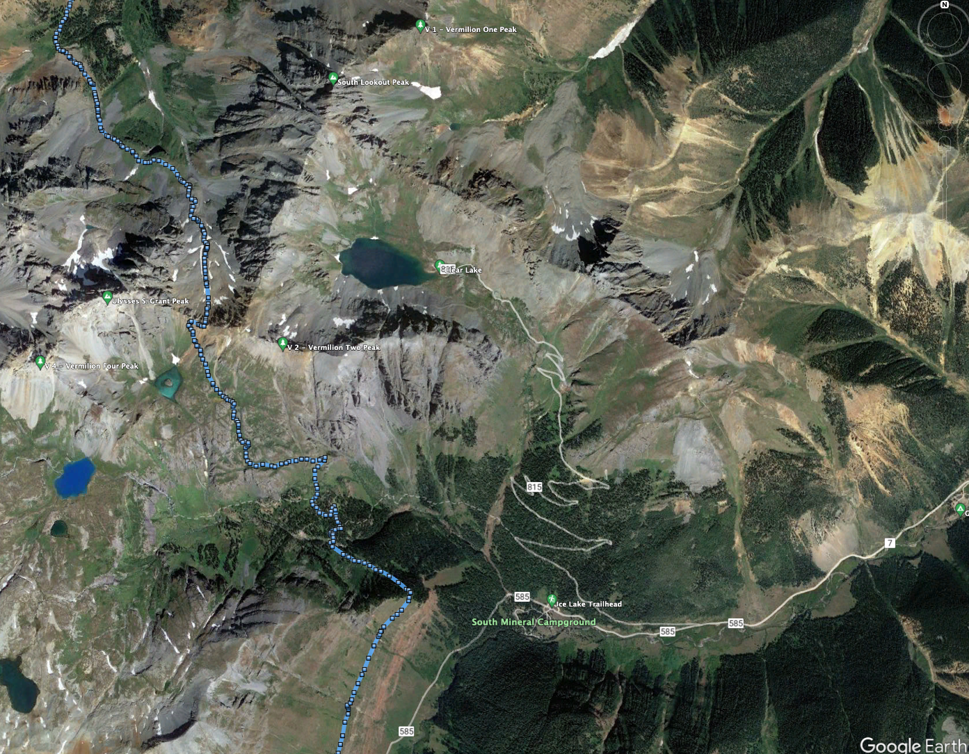
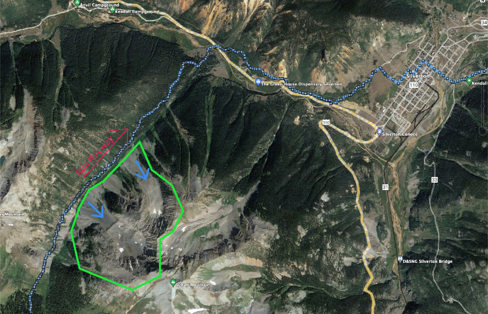
The last stretch along the ridgeline before descending into the valley of silverton has excellent exposures of landslides and slumps in the basin to the east of the Hardrock 100 route.
This takes you on a quick geological tour of the Hardrock 100 ultramarathon. Do you have any thoughts or questions?
Still Curious?
If you would like more information about the geology of Colorado, check out my book Colorado Rocks, available signed here, or at booksellers nationwide.
Do you have another race or area you would like to know more about the geology? Please, contact me!


Really enjoyed reading this, Magdalena!
Pingback: Trail Etiquette: Multi-use Trails - Bun on the Run
Pingback: Trail Running: Gear 101 - Bun on the Run