
Albuquerque, the largest metro area in New Mexico, is a great city for the outdoors. We have excellent access to mountains, rivers, and ranges of ecological and topographic options. Trails tend to be relatively uncrowded, though the recent pandemic has brought larger than normal numbers to the great outdoors. This is a compilation guide of the best of Albuquerque-area hiking.
Albuquerque fall is usually marked by the International Balloon Fiesta, which of course is not occurring this year. While we can still see numerous hot air balloons in the skies each morning, more people are turning our attention to our favorite fall activity: hiking.
I have compiled a list of my favorite Albuquerque area hikes, for a variety of hiker types, including the hardcore, children, run-able, stroller or other wheeled access, bragging rights, dog-friendly and more. These hikes generally require an hour or less driving from the Albuquerque area. Don’t be fooled into thinking there aren’t other great hiking areas in and around the city; these are simply a few of my personal favorites! Read on for info and inspiration.

Best for Year-Round Access:
Paseo del Bosque Trail
The Paseo del Bosque Trail extends over 16 miles one way throughout the central city of Albuquerque, running in paved and dirt paths along the length of the Rio Grande. A paved bike path built on the river levee extends on the east side of the river from Alameda at North to Rio Bravo at its southern end. Walking, running, and biking access crosses the major bridges, and dirt paths connect and intertwine on many of the smaller acequias, providing tens of more miles of dirt path to explore. Major access points include the Rio Grande Nature Center, Abq BioPark, Paseo del Norte and Alameda trail heads.

Foothills Trails: Trail 365
The Albuquerque foothills open space contain a wealth of trails, ranging from gentle, rolling loops to steep access to the higher reaches of the Sandia Mountains Wilderness. Trail 365 is over 12 miles in total length, from the base of the Sandia Tram at north to Camino de la Sierra at its southern end, giving spectacular views of the city and western skyline. The trail winds through Forest Service, city, and open space land areas, with major access points at Elena Gallegos, Indian School, Menaul and Copper. Most people do either the north or south sections of the trail, skipping the mid section that will require walking/running on paved neighborhood streets. Many trails loop off of this major trail, so loops of all lengths are possible. The trail is very popular with hikers, runners, and mountain bikers in abundance. Rock climbers can often be seen bouldering just off the trail.
Best for Fall Foliage:
Fourth of July Canyon
Located on the east side of the Manzano Mountains near the village of Torreon, Fourth of July Canyon is home to many maples that put on a spectacular red foliage show during autumn. The trailhead also hosts a campground (check Forest Service site for current status). The canyon trail is a 5 mile out-and-back trail, which is very popular. The trail also connects to the larger Manzano Crest Trail. It is approximately 1 hour 20 minute drive from central Abq to the trail head.
Aspen Vista

Aspen Vista Trail is an extremely popular dirt road trail in the mountains above Santa Fe. The trail gently gains elevation from just shy of 10,000 feet through grove after grove of aspens and conifer forest, topping out at Tesuque Peak, nearly at 12,000 elevation. The wide, dirt road makes an excellent location for social distance hiking, though on peak fall color days, parking can be difficult as the trail is hugely popular. This trailhead is also approximately 90 minutes from central Albquerque.
Best for Families with Big Kids
Piedra Lisa Waterfall
A short hike leads to a small canyon and cliffs of a dry waterfall. The hike in the Sandia Foothills starts at the Piedra Lisa Canyon Trailhead. The hike to the waterfall section is less than a mile, largely up the side of a sandy arroyo. Children (& adults!) can scramble and climb up the granite faces of the waterfall area. The trail to the top of the waterfall is well marked. The trail continues up the wash to join with other Sandia Mountain trails; a common loop meets the Embudito Trail.
Best for Families with Little Kids:
Travertine Falls
This 1 mile hike leads from Tijeras to a small waterfall. Like most water in the desert, the stream has variable amounts of water, sometimes, only a trickle flows over the face of the waterfall. The waterfall is formed of a rock called travertine. Travertine forms as mineral-rich waters flow out of the ground in this region, precipitating calcium carbonate.
Carlito Springs Open Space

This incredible trail has been closed for several years for renovation. Carlito Springs is located on the southeast face of the Sandia Mountains near the village of Tijeras. It encompasses 179 acres and ranges in elevation from 6,300 feet to 7,000 feet. It has now also been named to the National Park Service’s National Register of Historic Places. An easy ~1.5 mile hike loops the area and passes many historical areas.
Best for ADA Access:
Cienega Canyon Picnic Grounds & Interpretive Trail
A host of picnic areas and a paved and ADA-accessible interpretive trail wind through the many meadows of Cienega Canyon on the east side of the Sandias. A small stream flows through the picnic ground, providing excellent water play locations for little legs.

A 4-mile out-and-back trail joins the South Crest Trail but allows for exploration of the canyon at any distance. For those with longer legs, the trail form a loop with Faulty and Sulphur Canyon trails, or even continue on the South Crest Trail. Reserve a picnic site on the Forest Service website.
Best for Visitors:
Crest House Nature Trail 98
Go for big views and thin air and visit the Sandia Crest. This short loop starts at the parking lot as Trail #130, head south on the paved interpretive trail and forms a short loop on trail #98. Spectacular views to the east and west show off Albuquerque, the Rio Grande valley, and Mt. Taylor forms the western skyline. Interpretive signs give information on local ecology, geology, and more on this loop that returns through an alpine tree-lined trail. A slightly longer add-on leads you south to the Kiwanis Cabin, worth a trip to see the historic 1930s stone house built by the Civilian Conservation Corps (CCC) and the abundant fossils in the limestone blocks that make up the house! The Crest Trail itself extends for nearly 30 miles, however, visitors and residents alike can take in jaw-dropping views from the paved trail accessed at the Sandia Crest parking lot.
Best for Dogs:
Paseo del Bosque Trail

The Paseo del Bosque Trail extends over 16 miles one way throughout the central city of Albuquerque, running in paved and dirt paths along the length of the Rio Grande. A paved bike path built on the river levee extends on the east side of the river from Alameda at North to Rio Bravo at its southern end. Walking, running, and biking access crosses the major bridges, and dirt paths connect and intertwine on many of the smaller acequias, providing tens of more miles of dirt path to explore. Major access points include the Rio Grande Nature Center, Abq BioPark, Paseo del Norte and Alameda trail heads.
The cottonwoods provide ample shade cover, and easy water access is key for dogs in warm weather. Keep the pups leashed, as this is a very popular location!
Best for cool Geology:
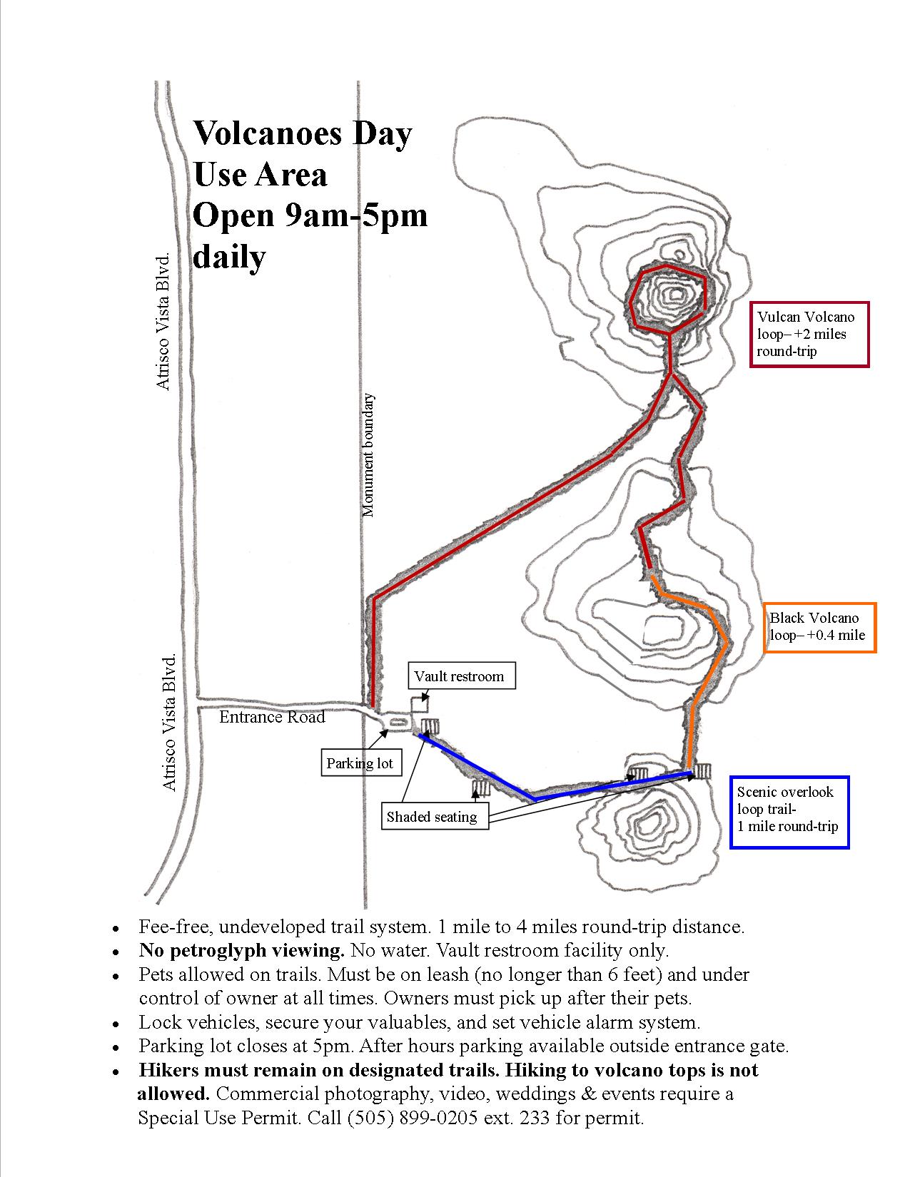
Volcanoes/Petroglyph National Monument
Petroglyph National Monument forms the western Albuquerque skyline. The basalt escarpment is a chain of 5 cinder cones, and the monument holds many petroglyph and other archaeological sites. There are four trails that give volcano and petroglyph viewing. These trails generally suggest spending an hour or more to hike between 1-2 miles. Some areas provide narrative information accessible via cell phone.

Kasha-Katuwe Tent Rocks National Monument
Tent Rocks offers slot canyon hiking through spectacular geological formations. Over 1000 feet of soft volcanic rock: pumice, ash, and tuff form towering “tents” or “hoodoos” that stand on the sides of narrow, twisting canyons. This soft volcanic rock is easily eroded by rain, snowmelt and wind. Much like an umbrella protects you from getting wet, a resistant caprock shelters the underlying soft ashy material, preserving it from being washed away. As the soft rock nearby it erodes away, a spire of protected rock emerges, forming a giant cone. This monument has guided paths, and the 3 mile “Slot Canyon Trail” out and back trail is extremely popular. Not for the faint of heart, the hike gains nearly 1000 feet, has some cliffy exposure and slippery trail surfaces. The monument is presently closed but stay tuned.
Best for Bragging Rights:
La Luz Trail #137
La Luz is perhaps the most “iconic” of Albuquerque trails, and often gets listed as the best of Albuquerque-area hiking. Switch-backing from NE Albuquerque, the La Luz trail is a steep, 14-ish mile hike (up & down) with nearly 3,600 feet elevation gain, ending at 10,678 feet elevation. The lower trail is packed dirt and rock, but the upper switchbacks are infamous for their many zig-zags through scree and boulder fields. Many people choose to hike up and ride the Tram down. The Tram which can be accessed from La Luz trail via Spur Trail #130. You can also arrange a carpool pick up at the top.

Sandia Crest Trail
If you want the ultimate skyline trail, the Sandia Crest Trail traverses the 27 miles from Placitas to Tijeras along the crest of the Sandia Mountains. The 27-mile one-way trip has nearly 6,000 feet elevation change. With spectacular views, changes in scenery and ecosystem, this trail is most often used for hiking and trail running. Users can backpack along the route, though water sources are limited. Water can be accessed at the top of the La Luz trail and at the top of the tram/restaurant. Many trails that rise from the city edge meet with the larger Crest Trail, so options for smaller loops and meet ups can be designed.

Do you have a favorite hike that’s not on this list? Why is it your favorite? Add it in comments below!


Reminds me how much I miss the Sandia foothills! For trail running, I loved the Embudito and Pino trails. Both are ~8 mile out and backs, with a good mix of terrain. My favorite time of the day to run those was just before sunset, because the sky is spectacularly colorful on the way back.